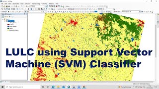
How to create Level-I Level-II and Level-III Land Use Land Cover(LULC) map using ArcGis.

#LULC#Level_I#Level_II#Level_III#SatelliteImage#ArcGis
Welcome to Remote Sensing GIS Home. Onestop platform for Remote Sensing and GIS Videos and Lectures on Remote Sensing and GIS Techniques and their applications. We want to provide a brief explanation of the Practical Portion of GIS & Remote Sensing.
RS GIS HOME Facebook Page:
/ rsgishome
RS GIS HOME Facebook Groups:
/ geospatialcommunity
Follow me on Linkedin: / santanughosh7714b3141
Join our Free Telegram Channel
Click here:https://t.me/rsgishome
Playlists:
Remote Sensing and GIS tutorial • Remote Sensing and GIS tutorial.
ArcGIS for beginners • Arcgis for beginners.
ArcGIS Model Builder • ArcGIS Model Builder
Excel to ArcMap • Excel to ArcMap
Google Earth Pro • Google Earth Pro
DGPS • DGPS
Satellite Data Download • Satellite Data Download
==========================================================================================
How to Download Sentinel2 satellite image through Tile or Grid no • How to Download Sentinel2 satellite ...
land use/land cover classification levels based on nrsc and isro (2011) https://bhuvanapp1.nrsc.gov.in/2dres...
_______________________________________________________________________________
Welcome to Remote Sensing GIS Home YouTube channel, we hope you like our videos.
Subscribe to our channel for the latest Videos and Lectures on Remote Sensing and GIS Techniques and their applications.
___________________________________________________________________________________
About the Video:
This video shows how to create a land use and land cover (LULC) map from a satellite image. Land use and land cover (LULC)map is an important research area and studied exclusively in remote sensing. However, accurate and appropriate land use/cover detection is still a challenge. This video shows that how to create different types of land use and land cover (LULC) based arc gis Digitatization using Sentinel 2 data.
If you like the information given in this video, first hit the like button and share the video with your friends.
Subscribe to the channel if you are new here and press the bell icon to get regular updates.
___________________________________________________________________________________
About the Channel:
On this YouTube Channel:
Knowledge of Remote Sensing and GIS and how it works in the world
Videos and Lectures on Remote Sensing and GIS Techniques and their applications
A brief explanation of Practical Portion of GIS & Remote Sensing
Boost your concept with Remote Sensing and GIS
Keep yourself updated with the new techniques of Remote Sensing and GIS field
Onestop platform for Remote Sensing and GIS
So stay connected with us by just clicking on the Red Subscribe button and press the bell icon.
___________________________________________________________________________________
Follow us on:
Facebook Page: / rsgis
Follow me on Linkedin: / santanughosh7714b3141
Thank You.