Grow your YouTube channel like a PRO with a free tool

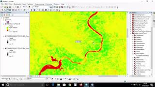
How To Create NDVI Maps in ArcGIS Pro

https://gisgeography.com/howtondvi...
Normalized Difference Vegetation Index or NDVI quantifies the amount of green vegetation using the reflectance of nearinfrared and red light wavelengths.
In this video, I'll create an NDVI map using ArcGIS Pro. Based on the NDVI values, I will also assess whether or not the values indicate vegetation, barren areas, or water bodies.


Recommended