It was never so easy to get YouTube subscribers

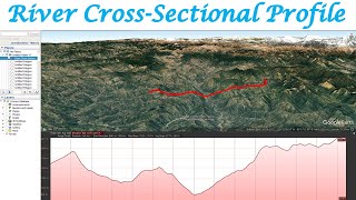
How to Create Profiles/Cross -Section for Channel/river using a DEM and 3D analyst tools in Arc-GIS

This video shows how you can generate profiles(Crosssection) from digital elevation models (DEMs). It's an awesome way to do some preliminary groundtruthing. Give it a try. I like using that software, it's very fun to see the channel(river) hydraulics and hydraulic jumps... And there's a free addon available for ArcMap. it's available for version 10.2 Arcmap.


Recommended