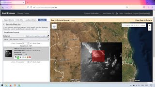
How to create river stream order map in ArcGIS | ArcGIS tutorial

In this video, you will learn how to visualize river stream order using ArcGIS software. I made this map using hydrology tools. You can also create your city drainage system just like the process I showed here.
1:09 Extract by mask
1:52 Fill
2:24 creating Flow direction raster
2:43 Creating Flow accumulation Raster
3:57 Using Raster Calculator
4:46 How to use stream order tool
5:21 Stream to feature(convert raster to vector)
6:17 using dissolve to merge the separated line
Subscribe to My channel for NEW VIDEOS EVERY DAY and make sure to enable Push Notifications so you'll never miss a new video.
All you need to do is PRESS THE BELL ICON next to the Subscribe button!
Download data for GIS: • Download data for GIS specially Lands...
Download shapefile: • How to download shapefile data GIS fo...
Delineate Watershed: • Watershed delineation from DEM using ...
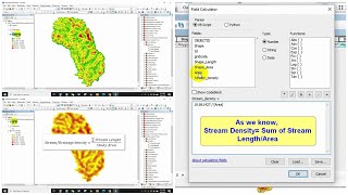
Calculate stream density: • How to calculate stream density using...
Learn ArcGIS software in this lecture series...
Check my Fiverr profile: https://www.fiverr.com/s2/df39f26a85
https://www.fiverr.com/s2/952b9deb55
Add me on Facebook https://facebook.com/profile.php?id=1...
Follow me on Instagram / kazialmuqtadir
Related tags: river stream order,stream order using arcgis,stream order from a digital elevation model,arcgis stream order vector,arcgis create stream network from dem,stream ordering,how to create drainage map in arcgis,stream order characteristics,stream to feature arcgis,delineating watersheds from a dem gis,stream order diagram,how to create watershed in arcgis,watershed,stream,stream order,drainage density,stream density,strahler classification
#almuqtadir_abir #river_stream_order #city_drainage_system


![The moment we stopped understanding AI [AlexNet]](https://i.ytimg.com/vi/UZDiGooFs54/mqdefault.jpg)