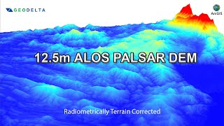
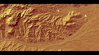
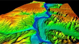
How to Download ALOS PALSAR DEM Radiometric Terrain Correction High Resolution DEM
This video provides a stepbystep procedure for downloading ALOS PALSAR DEM images. Alaska Satellite Facility provide free satellite image with high resolution 12.5 m DEM image.
Creation of radiometrically terrain corrected (RTC) products is a project of the Alaska Satellite Facility that makes SAR data accessible to a broader community of users. The project corrects synthetic aperture radar (SAR) geometry and radiometry, and presents the data in the GISfriendly GeoTIFF format (Source: https://asf.alaska.edu/datasets/deri....
#ALOS_PALSAR
#highresolution
#demonslayer
#Alaska_Satellite_Facility
#usgs
#landsat
#srtm
#degitalevelationmodel
#Software
#GIS
#GIS_Software
#QGIS
Link of Image to image georeferencing:
• How to do Image t...
Link of Raster image georeferencing:
• How to do Georefe...
Link of Raster image digitization:
• How to do Digitiz...
Choropleth Map Preparation using QGIS 2020:
• How to prepare a ...
NDVI Calculation:
• How to do NDVI Ca...
Follow the Link for more videos:
• Video
• How to Geo Refere...
• How to create Thi...
• How to merge over...
• How to Create Riv...
• How to Create Mul...
• Change Detection ...
• Change Detection ...
• How to download L...
• Accuracy assessme...
• How to download D...
• How to download W...
• How to create 3D ...
• Land Use Land Cov...
• How to create DEM...
• How to create DE...
• How to create Con...
Contact: [email protected]