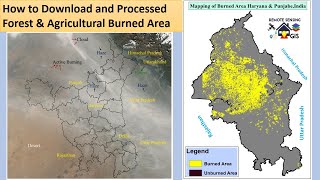
How to download Forest and Agricultural Residues active fire location data

#forestfire #forestfires #agriculturalresidus #forestfiredata #burnedareadata#activefirelocationdata#nasa #nasafirms#agriculturalfiredata
Hi, viewer In this tutorial, you will learn How to download Forest and Agricultural Residues active fire location data.
In order to find active fires and thermal anomalies, NASA FIRMS employs satellite observations from the MODIS and VIIRS instruments. It then notifies decisionmakers of these findings in almost realtime via email alerts, data that is ready for study, online maps, and web services. Hot spots are detected by MODIS' thermal band with a resolution of 1,000 meters per pixel and by VIIRS with a resolution of 375 meters per pixel. In other words, compared to MODIS, VIIRS makes fire observations that are approximately three times more detailed. The active fire location data is used for mapping forest fires and agricultural residue fires. The data also applications such as earth observation, vegetation monitoring, and environmental pollution assessment, among others.
If you like this video, you can SUBSCRIBE to this channel to get new video updates on GIS & Remote Sensing. Thank you.
Stubble burning and wildfires are major environmental hazards in all most all parts of the world. The problem is more intense in developing countries, especially in India, China, and Malaysia due to weather and topographic pattern. Agriculture mechanization to increase crop productivity and decrease labor costs in order to fulfill food security demands for its rapidly growing population is considered a key catalyst for stubble burning (Mehta et al., 2014). This may lead to a huge quantity of rice residues with a large potential for pollutant emissions after burning. Lightning is mostly responsible for naturally occurring wildfires. Depending on the situation, there can also be coal seam, volcanic, and meteor fires. Wildfires started by people might be unintentional (arson), on purpose, or as a result of carelessness.
Typical applications include:
i) Mapping of Crop Residual Burning
ii) Mapping of Forest Fire
iii) Evapotranspiration models
iv) Climate Change modeling
v) Assessing Forest burned areas
vi) Find the variation in groundwater level due to Crop Residual Burning
vii) Vegetation Monitoring
Related Tags: how to download forest fire data, how to download agricultural burned area data, how to map forest fire, how to map crop residual burned area, how to download burned area data, how to download, forest fires, wildfires, gis remote sensing, NASA firms, active fire location, how to download active fire location, MODIS, VIRSS,
If you have any queries, Feel free to write me in the comment section. I'll try to answer all of your queries.
Join our Free Telegram Channel:
https://t.me/rsgishome
Facebook Page:
/ rsgishome
RS GIS HOME Facebook Groups:
/ geospatialcommunity
Follow me on Linkedin:
/ santanughosh7714b3141
===========================================================================
Playlists:
Geomatics Engineering Gate 2022 || Free Course:
• Geomatics Engineering Gate 2022 || Fr...
Remote Sensing and GIS tutorial:
• Remote Sensing and GIS tutorial.
ArcGIS for beginners:
• Arcgis for beginners.
ArcGIS Model Builder:
• ArcGIS Model Builder
Excel to ArcMap:
• Excel to ArcMap
Google Earth Pro:
• Google Earth Pro
DGPS :
• DGPS
Satellite Data Download:
• Satellite Data Download
________________________________________________________________________
About the Channel:
On this YouTube Channel:
Knowledge of Remote Sensing and GIS and how it works in the world
Videos and Lectures on Remote Sensing and GIS Techniques and their applications
A brief explanation of Practical Portion of GIS & Remote Sensing
Boost your concept with Remote Sensing and GIS
Keep yourself updated with the new techniques of Remote Sensing and GIS field
Onestop platform for Remote Sensing and GIS
Video Lectures & Study Material in Geomatics Engineering(GE for GATE)
So stay connected with us by just clicking on the Red Subscribe button and pressing the bell icon.
___________________________________________________________________________________
Reference
The presentation has been compiled from various sources such as books, tutorials (online and offline), internet. The information in this lecture /presentation is for general information and education purposes.
Thank You.