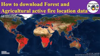
How to download Forest Fire u0026 Agricultural Residues Burned Area Data part I

#forestfire#agriculturalresidus#burnedareadata#modisburnedproduct#MCD64A1
Hi, viewer In this tutorial, you will learn how to download Forest Fire & Agricultural Residues MODISbased burnt area product.
MODIS is a NASAs satellite with 36 spectral bands of various spectral ranges (405–14385 nm) and is used for a multitude of applications such as earth observation, vegetation monitoring, and environmental pollution assessment, among others. Details of bands and their applications may be obtained at
https://modis.gsfc.nasa.gov/about/spe...
MODISbased burnt area product is developed using a burnsensitive normalized vegetation index (VI) derived from atmospherically corrected surface reflectance of MODIS shortwave infrared channels 5 (central wavelength = 1240 nm) and 7 (central weave length = 2130 nm) and a measure of temporal texture. Details of the algorithm may be obtained from Giglio et al. (2018). The product may be downloaded from
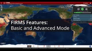
https://search.earthdata.nasa.gov/
https://earthexplorer.usgs.gov/
**Mapping of Forest Fire & Agricultural Residues Burned Area
• Mapping of Forest Fire & Agricultural...
If you like this video, you can SUBSCRIBE to this channel to get new video updates on GIS & Remote Sensing. Thank you.
Application of Forest Fire & Agricultural Residues Burned Area Data
Stubble burning is one of the major environmental hazards in all most all parts of the world. The problem is more intense in developing countries, especially in India, China, and Malaysia due to weather and topographic pattern. Agriculture mechanization to increase crop productivity and decrease labor costs in order to fulfill food security demands for its rapidly growing population is considered a key catalyst for stubble burning (Mehta et al., 2014). This may lead to a huge quantity of rice residues with a large potential for pollutant emissions after burning.
Typical applications include:
i) Mapping of Crop Residual Burning
ii) Mapping of Forest Fire
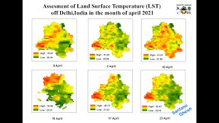
iii) Evapotranspiration models
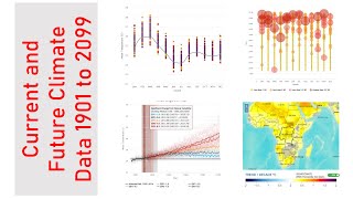
iv) Climate Change modeling
v) Assessing Forest burned areas
vi) Find the variation in groundwater level due to Crop Residual Burning
vii) Vegetation Monitoring
Related Tags: how to download forest fire data, how to download agricultural burned area data, how to map forest fire, how to map crop residual burned area, how to download burned area data, how to download, satellite data, forest fires, wildfires, gis remote sensing, modis,
crop residues burned data, agricultural fire
If you have any queries, Feel free to write me in the comment section. I'll try to answer all of your queries.
Join our Free Telegram Channel:
https://t.me/rsgishome
Facebook Page:
/ rsgishome
RS GIS HOME Facebook Groups:
/ geospatialcommunity
Follow me on Linkedin:
/ santanughosh7714b3141
===========================================================================
Playlists:
Geomatics Engineering Gate 2022 || Free Course:
• Geomatics Engineering Gate 2022 || Fr...
Remote Sensing and GIS tutorial:
• Remote Sensing and GIS tutorial.
ArcGIS for beginners:
• Arcgis for beginners.
ArcGIS Model Builder:
• ArcGIS Model Builder
Excel to ArcMap:
• Excel to ArcMap
Google Earth Pro:
• Google Earth Pro
DGPS :
• DGPS
Satellite Data Download:
• Satellite Data Download
________________________________________________________________________
About the Channel:
On this YouTube Channel:
Knowledge of Remote Sensing and GIS and how it works in the world
Videos and Lectures on Remote Sensing and GIS Techniques and their applications
A brief explanation of Practical Portion of GIS & Remote Sensing
Boost your concept with Remote Sensing and GIS
Keep yourself updated with the new techniques of Remote Sensing and GIS field
Onestop platform for Remote Sensing and GIS
Video Lectures & Study Material in Geomatics Engineering(GE for GATE)
So stay connected with us by just clicking on the Red Subscribe button and pressing the bell icon.
___________________________________________________________________________________
Reference
The presentation has been compiled from various sources such as books, tutorials (online and offline), internet. The information in this lecture /presentation is for general information and education purposes.
Thank You.