Get real, active and permanent YouTube subscribers

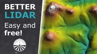
How to download free LiDAR data online using USGS Earth Explorer

This tutorial walks you through the process of downloading free LiDAR data online using the USGS Earth Explorer.
Other websites offering free LiDAR Data:
Open topography: http://www.opentopography.org/
National LiDAR Dataset (U.S.): https://en.wikipedia.org/wiki/Nationa...)
NOAA Digital Coast (specifically for coastal areas): https://www.coast.noaa.gov/dataviewer/#/
National Ecological Observatory Network (NEON): http://www.neonscience.org/
Feel free to share other sources that you have found useful in the comment section below.


Recommended