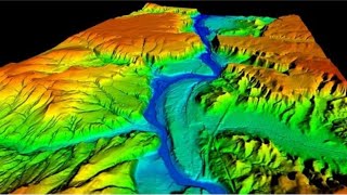
How to download high resolution digital elevation model (12.5 m) |

The video shows how to download high resolution digital elevation model (12.5) for any area in the world.
https://search.asf.alaska.edu/#/
LinkedIn: / sanaullahsalam987766158
Twitter: / sana_ullah_afg
Facebook: / sana.afghan.92167
Attached links illustrate how to download some of the most useful data in remote sensing and geography domain.
1. How to download shapefiles of rivers, basins, lakes etc.
• How to download shapefiles of major b...
2. How to download latest land use land cover data (10 m resolution)
• How to download latest Land Use Land ...
3. How to download digital elevation model (30 m) for any area in the world
• How to download Digital Elevation Mod...
4. How to make land use land cover map
• How to make land use and land cover m...
5. How to download freely discharge data of 10,696 hydrological stations in the world
• How to download discharge data of 10,...


![The moment we stopped understanding AI [AlexNet]](https://i.ytimg.com/vi/UZDiGooFs54/mqdefault.jpg)