How to Download Hyperion Hyperspectral Satellite Image | Hyperspectral Satellite Image Download

How to Download Hyperion Hyperspectral Satellite Image | Hyperspectral Satellite Image Download
About this Video
Are you eager to explore the fascinating world of hyperspectral satellite imagery? Look no further! In this comprehensive tutorial, we'll walk you through the stepbystep process of downloading Hyperion hyperspectral satellite images from two popular platforms: GloVis and EarthExplorer.
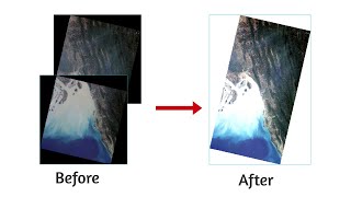
Hyperion imagery provides unparalleled spectral detail, enabling us to study and analyze the Earth's surface like never before. Whether you're a researcher, environmental enthusiast, or just curious about our planet's diverse characteristics, this video will equip you with the knowledge to access and utilize these extraordinary datasets.
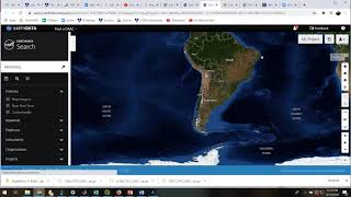
In the first part of the tutorial, we'll dive into the GloVis platform. We'll guide you through the creation of an account, providing useful tips and tricks to make the process seamless. Once you're logged in, we'll demonstrate how to navigate GloVis and identify the Hyperion dataset you're interested in. We'll cover selecting the desired location, date range, and other parameters to refine your search. Furthermore, we'll discuss how to view metadata, explore thumbnail images, and finally, download the chosen Hyperion hyperspectral satellite image effortlessly.
In the second part of the tutorial, we'll shift our focus to EarthExplorer, another valuable resource for accessing satellite imagery. We'll outline the steps to create an account, emphasizing key aspects that may enhance your experience. We'll then show you how to navigate EarthExplorer and input the necessary criteria to narrow down your search for Hyperion imagery. We'll discuss the various search options available, such as location, time period, and dataset selection. Finally, we'll walk you through the download process, ensuring you obtain the Hyperion hyperspectral satellite image you desire.
Throughout the tutorial, we'll provide insightful explanations, tips, and best practices to optimize your experience when working with GloVis and EarthExplorer. By the end of this video, you'll feel confident in your ability to download Hyperion hyperspectral satellite images and embark on your exploration of our planet's spectral intricacies.
Join us in this exciting journey and unlock the door to the mesmerizing world of Hyperion hyperspectral satellite imagery! Don't forget to like, comment, and subscribe to our channel for more tutorials on remote sensing, satellite imagery, and cuttingedge technologies. Hit the notification bell to stay updated with our latest uploads. Happy downloading!
#gis #remotesensing #hyperspectral #hyperion #satelliteimagery #satellite #dawnofgeospatialworld
Various Space Agencies & Missions: • Space Agencies & Earth Observing Miss...
Data Download Processes for GIS Work: • Download Data for GIS & Remote Sensin...
QGIS Basics Tutorials: • QGIS Basics Tutorials
ArcMap Basics Tutorials: • ArcMap Basics Tutorials
The following geospatial and environmental solutions video instruction is available on this channel:
ArcGIS, QGIS (Geospatial Analysis, Monitoring)
Cartography
Basics of Mapmaking
Basics of GIS & Remote Sensing
Google Earth Engine
You can watch our videos on YouTube : @dawnofgeospatialworld
If you think they're useful, kindly subscribe to our channel.
Follow us on Instagram : / dogw_official
Join our Facebook Group : / dogw.official
Thank you So Much.....