Get real, active and permanent YouTube subscribers

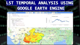
How to download IMERG 30 Minutes rainfall data in excel using Google earth Engine

In my recent tutorials, I demonstrated how to download onehour GsMap data and prepare it for RainfallRunoff Inundation model (RRI). However, challenges encountered when the correlation between GsMap and observed gauge data is low. To address this, IMERG data as an alternative can be used. In this brief tutorial, I'll guide you through the steps to download IMERG rainfall datasets using Google Earth. Please note that while I'm not a professional tutorial creator, I hope this guide proves helpful to those seeking to integrate IMERG data into their analyses.
Code link.
https://code.earthengine.google.com/4...
#GEE, #Hydrology #RRI, #Runoff, #Inundation


Recommended