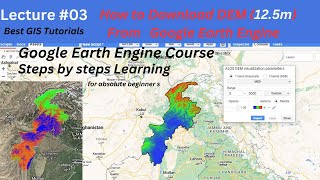
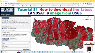
How to Download Landsat 9 Images from USGS Earth Explorer

Welcome to Best GIS Tutorials. Good news
Fist of all Thanks for USGS and NASA for their efforts
From now Landsat 9 data (images) are available according to USGS.
Now you can download Landsat 9 Collection 2 Level1 and Level2 data from Earth Explorer.
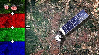
there are two science instruments have been carried by the satellite (LC9) which are the Operational Land Imager 2 (OLI2) and the Thermal Infrared Sensor 2 (TIRS2) for capturing observations of the Earth’s surface in visible, nearinfrared, and shortwaveinfrared bands and measuring thermal infrared radiation, or heat, emitted from the Earth’s surface, respectively. Landsat 9 has higher radiometric resolution for OLI2 (14bit quantization) which allowing sensors to detect more subtle differences
Best GIS Tutorials is platform to help those people who want to develop their Skill we provide all the basics of Geographic information System From Beginner to Advance level such is how to georeference a map, how to digitize a map, how to download google earth image, how to download Satellite image for research, use of merge tool, how to make study area map, how to make layout for map. these are the some of basic and the main topics that we will provide in the form of tutorial videos and as well lecture in pdf form. Best GIS Tutorials is providing free opportunity to every students to learn and equipt will skills for a bright future.
Subscribe Best GIS Tutorials to understand Geographic Information System in simple way.
keep in touch with us.
=========================================
~~~~~~~~~ Subscribe our Channel~~~~~~~~~


![The moment we stopped understanding AI [AlexNet]](https://i.ytimg.com/vi/UZDiGooFs54/mqdefault.jpg)