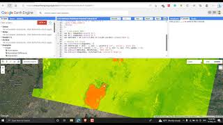
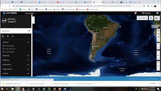
How to Download MODIS NDVI | LST | ASTER DEM | Spatial data from Earth data web

NASA's Earth Science Data Systems (ESDS) Program oversees the life cycle of NASA’s Earth science data — from acquisition through processing and distribution. The primary goal of ESDS is to maximize the scientific return from NASA's missions and experiments for research and applied scientists, decisionmakers, and society at large.
ESDS data systems and science products continuously evolve through a combination of competitive awards and sustained and strategic investments in open data, international and interagency partnerships, and a set of standards that ensure consistency and interoperability. Since 1994, Earth science data have been free and open to all users for any purpose, and since 2015, all data systems software developed through research and technology awards have been made available to the public as Open Source Software (OSS).
ESDS falls within the purview of the Earth Science Division (ESD), under the Science Mission Directorate (SMD) at NASA Headquarters.