How to download Sentinel-2 imagery in QGIS

Found this helpful? Buy me a coffee on KoFi: https://kofi.com/amdgs
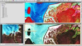
A tutorial on how to download the European Space Agency's Sentinel2 satellite imagery ready for analysis in QGIS. The freely available Sentinel2 imagery stretches back to June 2015 and with a return period of around 5 days (not accounting for cloud cover!) it provides a powerful data source for a whole range of applications including ecology, agriculture, mapping and more keep an eye on my other videos for tutorials on some of the things you can do.
This video sets you up with everything you need to identify the right Sentinel2 data product for your study area, narrow down images by date and cloud cover and download them ready for further GIS analysis.
If you find the video useful, please like and subscribe enough subscribers will eventually allow me to monetise my content and support me in producing even more in the future!