The easiest way to skyrocket your YouTube subscribers

How to extract NDVI from Landsat 8 Satellite Imagery Data in ArcGIS?

By: Dr. Abe Mollalo
00:00 Introduction to Landsat 8
03:03 How to download Landsat imagery data?
08:32 Unzip and explore the bands
11:49 Load the data into ArcMap
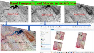
13:09 Create a composite band
15:58 Common band combinations
17:48 Introduction to vegetation index (NDVI)
20:18 Measure NDVI in GIS
23:40 Habitats of ticks relative to NDVI
30:27 Other applications of NDVI in Public Health
Source of tick data:
Arkansas Department of Health
Download the data (except Landsat data) used in this video tutorial:
https://github.com/DrMollalo/GISData/...
Download Landsat 8 satellite imagery data (Path: 24, Row: 36):
https://glovis.usgs.gov/


Recommended