The easiest way to skyrocket your YouTube subscribers

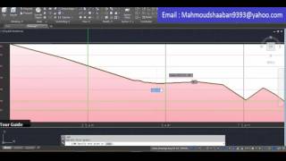
How to Generate and Interprete Elevation Profile in Google Earth Pro

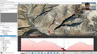
The elevation profile is a tool that can be utilized to view and and get an understanding of the ground terrain of a region of interest. Using the Google earth pro application, you can digitize a transect/path of walking track or a road in order to visualize the terrain of the route in three dimensional view. Kindly SUBSCRIBE for more educative videos.
How to download and install Google Earth pro: • How to Download and Install Google Ea...


Recommended