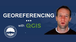
How to Geo Referencing of Topographical Map in QGIS
This is the tutorial of QGIS map making. In this tutorial, you will learn about the georeferencing by using QGIS 3.10. Georeferencing a raster map in qgis is very simple work. .
For more information please send mail: [email protected]
#georeferencing
#qgistutorial
#georeferencinginqgis
#qgis3.10
#Software
#GIS
#GIS_Software
#erdas
#erdas14
Link of Image to image georeferencing: • How to do Image to Image Georeferenci...
Link of Raster image georeferencing: • How to do Georeference a Raster map i...
Link of Raster image digitization: • How to do Digitization with QGIS 2020...
Choropleth Map Preparation using QGIS 2020: • How to prepare a Choropleth Map Prepa...
NDVI Calculation: • How to do NDVI Calculation in QGIS II...
Follow the Link for more videos:
• Video
• How to Geo Referencing of Topographic...
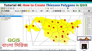
• How to create Thiessen Polygons in QG...
• How to merge overlapped Landsat Band...
• How to Create River and City Points M...
• How to Create Multiple Buffer Zone in...
• Change Detection Analysis of Land use...
• Change Detection Analysis of Land use...
• How to download Land use and Land cov...
• Accuracy assessment of Landuse and La...
• How to download District River, Road,...
• How to download World Shape file and ...
• How to create 3D Model of DEM image u...
• Land Use Land Cover Map of Landsat 8 ...
• How to create DEM from Google Earth I...
• How to create DEM (Elevation Map) an...
• How to create Contour line and DEM (E...
• Land Use Land Cover Classification (S...
• How to Create Study Area Map Using Go...
• How to Add Excel file CSV with Shape ...