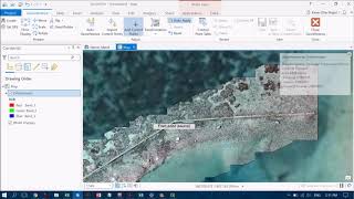
How to Georeference in ArcGIS Pro

Found this helpful? Buy me a coffee on KoFi: https://kofi.com/amdgs
A quick but comprehensive guide to georeferencing raster layers in ArcGIS Pro. It talks through how to find the tools, the georeferencing process itself and provides some useful tips for producing an accurate georeferencing result.
Georeferencing is the process of aligning a GIS layer (usually a raster map) that has no location information attached to it, with other layers that have location information. This allows you to take a 'dumb' layer and turn it into something that you can use for analysis take measurements, digitise features and relate your layer to other spatial datasets. Georeferencing is a fundamental skills for any GIS user, but can often be tricky and frustrating when you're just starting out. The tips in this how to guide will hopefully make life a bit easier!
If you find this guide useful, please like and subscribe and check out my other videos!