Buy real YouTube subscribers. Best price and warranty.

How to Georeferencing a topographic sheet using erdas imagine 14

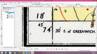
Georeferencing is the name given to the process of transforming a scanned map or aerial photograph so it appears “in place” in GIS. By associating features on the scanned image with real world x and y coordinates, the software can progressively warp the image so it fits to other spatial datasets.
Georeferencing is to establish a relationship between images and object coordinate systems. It is crucial to make satellite and aerial as well as terrestrial imagery useful for mapping.
#Georeferencing
#Toposheet
#Topographic_map
#Pakistan_map
#Erdas_Imagine_14


Recommended