A little secret to rock your YouTube subscribers

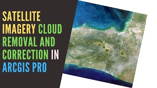
How to get Radiometric and Atmospheric Corrected Sentinel-2 Imagery and Manage it in ArcGIS Pro

How to get radiometric and atmospherically corrected Sentinel2 Imagery and how to manage the data in ArcGIS Pro.
This video is made for you who still looking for a fast and easy way to get atmosphericcorrected satellite imagery especially Sentinel2 Imagery.
Music by: www.bensound.com
#sentinel2 #arcgispro #satelliteimagery #atmosphericcorrection


Recommended