How to Make Contour Map from DEM in ArcGIS 10.8

1 Introduction to ArcMap Interface. Exploring the ArcGIS 10.8 Version.
• Introduction to ArcMap Interface. Exp...
2 How to Add & Display Vector data in arcgis 10.8
• How to Add & Display Vector data in ...
3 How to Add and display Raster data in Arcgis 10.8
• How to Add and display Raster data in...
4 How to download shapfile for any Region From Diva GIS
• How to download shapfile for any Regi...
5 Calculate Geometery of An area in Arcgis.
• Calculate Geometery of An area in Arc...
6 Download DEM from USGS Earthexplorer Using Shapefile.
• Download DEM from USGS Earthexplorer ...
7 How to dissolve Polygon Shapefiles using ArcGIS.
• How to dissolve Polygon Shapefiles us...
8 How to extract area of interest by Mask using ArcGIS 10.8 Version
• How to extract area of interest by Ma...
9 Editing & Creating Shapefile from Image in ArcGis 10.8.
• Editing & Creating Shapefile from Ima...
10 Buffering a Road and Wells in ArcGIS.
• Buffering a Road and Wells in ArcGIS.
11 How to clip data in arcgis 10.8
• How to clip data in arcgis 10.8
12 Adding & Creating New Point Shapefile Data in ArcGIS 10.8
• Adding & Creating New Point Shapefile...
13 Making Contour Map from Point Data Using Kriging Method in ArcMap
• Making Contour Map from Point Data Us...
14 How to add Basemap in Arcmap.
• How to add Basemap in Arcmap.
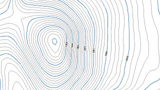
15 How to Make Contour Map from DEM in ArcGIS 10.8
• How to Make Contour Map from DEM in A...
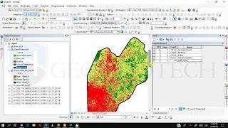
16 Classifying Vector Data Polygon Shapefile in ArcGIS 10.8
• Classifying Vector Data Polygon Shape...
17 Create Random Points and extracting values in ArcGIS 10.8
• Create Random Points and extracting v...
18 Extracting Raster DEM Values Via Points .shp
• Extracting Raster DEM Values Via Poin...
19 Create Profile of Watershed from DEM Using ArcGIS 10.8
• Create Profile of Watershed from DEM ...
20 Downloading USGS Earthexplorer Data via Shapefile. & Displaying in ArcGIS 10.8
• Downloading USGS Earthexplorer Data v...
21 Creating Heat Map Using Stations Data in ArcGIS 10.8
• Creating Heat Map Using Stations Data...
22 Creating Population Map of Afghanistan for Year 2020 in arcgis
• Creating Population Map of Afghanista...
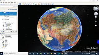
23 Creating line feature or Road Data from Google Earth| Digitization of Road Data
• Creating line feature or Road Data fr...
24 Spatial Analysis of Point Data using Select Layer by Location tool in Arcgis.
• Spatial Analysis of Point Data using ...
25 Create Contour Map by model builder in ArcGIS 10.8
• Create Contour Map by model builder i...
26 Download High Resolution Digital Elevation Model ALOS PALSAR DEM 12.5m Resolution
• Download High Resolution Digital Elev...
27 How to download High Resolution 10m Sentinel2 Data|USGS Earth Explorer| ArcGIS 10.8
• How to download High Resolution 10m S...
28 How to Download Earthquake data| USGS Earthquake| ArcGIS| ArcMap| CSV Format
• How to Download Earthquake data| USGS...
29 How to Download Open Street Maps| OSM Data| ArcGIS| ArcMap 10.8 Version
• How to Download Open Street Maps| OSM...
30 How to Download Geological Data & Display in ArcGIS| ArcMap| Geo technologies
• How to Download Geological Data & Dis...
31 Watershed Delineation Using SRTM| ALOS PALSAR| DEM Data| Arcmap 10.8
• Watershed Delineation Using SRTM| ALO...
32 How to Create River Network Order| Stream Order| ArcGIS| Arcmap 10.8
• How to Create River Network Order| S...