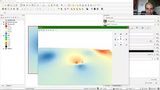
How to prepare Ground water level map or Depth to water level map using Arcgis || IDW

In this Video we will learn How to prepare Ground water level map or Depth to water level map using Arcgis.
Groundwater level is a term that is used in a relatively loose way, normally referring to the level, either below ground or above ordnance datum, at which soil or rock is saturated. This is also referred to as the water table and represents the top of the saturated zone.
QGIS Video
Lesson1: • QGIS Lesson1 QGIS absolute beginners...
lesson2 : • QGIS Lesson2 Digitization in QGIS, D...
Lesson3: • QGIS Lessons3 Interface of Google Ea...
Lesson4: • QGIS Lessons4 Download DEM,Create Sl...
Lesson5: • QGIS Lessons 5 Visualization of DEM i...
Contact
Any Help Contact
Mr.Vikas [email protected]
WhatsApp Number= +918421031398
Tags,
Water Level Map, Ground water level map, depth to water level map, IDW, Interpolation, conversion degree minute second to degree decimal, excel data add in Arcgis