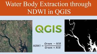
How to Prepare Normalized Difference Water Index (NDWI) and Extract Water Bodies from NDWI

How to Prepare Normalized Difference Water Index (NDWI) and Extract Water Bodies from NDWI.
Normalized Difference Water Index (EOS Data Analytics): https://eos.com/makeananalysis/ndwi/
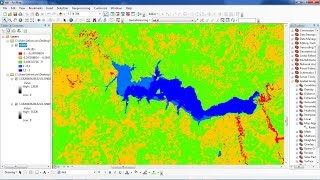
The Normalized Difference Water Index (NDWI) is used to highlight open water features in a satellite image, allowing a water body to “stand out” against the soil and vegetation.
Join our telegram Group Remote Sensing & GIS Professionals: https://t.me/joinchat/UhUorR2yhloKeKP...
Any Help Contact
Mr.Vikas [email protected]
WhatsApp Number= +918421031398
WhatsApp Chat:https://wa.me/+918421031398
Geotech GIS Training institute is a prestigious remote sensing training institute in India. Our vision is to bring an opportunity to every aspirant who dreams of a successful career in remote sensing and GIS field.
We conduct the following courses:
Training Program Related to Project Work Duration 1 Month
Basics of Remote Sensing and GIS Duration 3 Months
Advance Diploma in Remote Sensing and GIS Duration 6 Months
PG Diploma in Remote Sensing and GIS Duration 1 Year
Master of Remote Sensing and GIS Duration: 2 Years
You May Like
Population Density Data: https://www.census2011.co.in/census/s...
Diva GIS Shapefile: https://www.divagis.org/gdata
RS & GIS QA15 Download readytouse contour lines from Open DEM & Generate DEM from Contour: • RS & GIS QA15 Download readytouse ...
Land Use Land Cover Mapping in QGIS: • Land Use Land Cove (LULC) Mapping usi...
How to Download Landsat 9 Data set from USGS earth Explorer: • How to Download Landsat 9 Data set fr...
Download Rainfall data: • Download rainfall data from CHRS Data...
Download SOI Toposheet : • New Survey of India Website to Downlo...
Google earth Playlist : • Google Earth Hands On
ArcGIS : • ARC GIS
QGIS: • QGIS Lesson
Tags,
#NDWI
#WaterBodyExtraction
#RemoteSensing
#SatelliteImagery
#GIS
#GeospatialAnalysis
#ImageProcessing
#WaterDetection
#EnvironmentalMonitoring
#Hydrology