How to Reclassify Raster using QGIS

Raster Reclassification
Reclassifying a raster involves changing the values of the cells in the raster based on a specified criteria or rule set. This process is often used in GIS (Geographic Information Systems) analysis for various purposes like land cover classification, suitability analysis, or creating thematic maps.
Reclassifying a raster is often necessary to simplify or refine the data for specific analytical or visualization purposes. Here are some common reasons why reclassification of a raster might be required:
1. Simplification: Raster datasets often contain a wide range of values representing continuous phenomena (e.g., elevation, temperature). Reclassification allows you to group these values into a smaller number of categories, making the data easier to interpret and analyze.
2. Categorization: Reclassification enables the conversion of continuous data into categorical data. This can be useful for thematic mapping, where you want to represent different classes or types of features (e.g., land cover types, soil types) using distinct categories.
3. Data standardization: Rasters obtained from different sources may have different value ranges or units of measurement. Reclassification can help standardize the data by converting it to a common scale or set of categories, facilitating comparisons and integration with other datasets.
4. Analysis requirements: Certain types of spatial analysis or modeling may require the input raster to be in a specific format or with predefined categories. Reclassification allows you to prepare the raster data to meet the requirements of the analysis or model being performed.
5. Visualization: Reclassification can be used to enhance the visual representation of raster data by highlighting specific features or patterns of interest. For example, you might reclassify elevation data to emphasize different terrain features such as valleys, hills, and mountains.
6. Decisionmaking: Reclassified rasters can provide actionable information for decisionmaking processes in various fields such as environmental management, urban planning, and natural resource conservation.
Overall, reclassification of raster data is a fundamental preprocessing step in GIS analysis, allowing analysts to tailor the data to suit specific project objectives and requirements.
Now, let's explore how reclassification can be applied to both Land Use/Land Cover (LULC) data and Digital Elevation Model (DEM) data:
1. Land Use/Land Cover (LULC) data:
• Simplification: LULC data often contain detailed classifications that may not be necessary for certain analyses. Reclassification can simplify these classifications into broader categories, such as converting multiple land cover types (e.g., grassland, shrubland, forest) into a single "vegetation" class.
• Categorization: Reclassifying LULC data into thematic categories (e.g., urban, agricultural, water, natural) allows for easier interpretation and integration with other datasets. This categorical representation is commonly used for land management, urban planning, and environmental assessments.
• Analysis requirements: Some analyses require specific land cover classes to be aggregated or separated. For example, in habitat suitability modeling, reclassifying land cover types to differentiate between suitable and unsuitable habitats for a particular species can be crucial.
• Visualization: Reclassified LULC data can be visually appealing and informative for map production and presentation. By highlighting key land cover categories, such as urban areas or protected areas, decisionmakers can better understand spatial patterns and trends.
2. Digital Elevation Model (DEM) data:
• Simplification: DEMs often represent continuous elevation values, which can be complex to interpret. Reclassifying elevation ranges into categories such as low, medium, and high terrain simplifies the data for visualization and analysis.
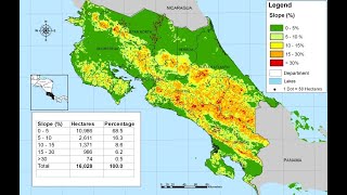
• Categorization: Reclassifying DEM data into slope categories (e.g., flat, gentle, moderate, steep) is useful for terrain analysis and landform characterization. This categorization helps in identifying areas prone to erosion, landslides, or suitable for different types of land use.
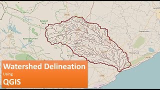
• Analysis requirements: Some analyses, such as hydrological modeling, require DEMs to be reclassified based on elevation thresholds to delineate watershed boundaries or identify drainage networks.
• Visualization: Reclassified DEMs can be visually impactful for terrain visualization and understanding landscape features. For example, a colorcoded elevation map created by reclassifying elevation ranges can effectively convey information about topographic variations.
In both LULC and DEM data, reclassification plays a crucial role in simplifying, categorizing, and preparing the data for various analyses and visualization purposes, ultimately aiding decisionmaking processes in fields like environmental management, urban planning, and natural resource assessment.


![Fire Risk Zonation or Assessment On ArcGis by Different Methods [English]](https://i.ytimg.com/vi/wwccFbNFyLU/mqdefault.jpg)