YouTube doesn't want you know this subscribers secret

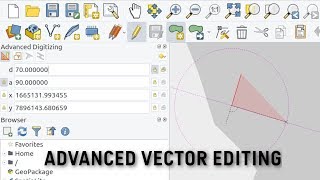
How to Subdivide a Parcel (QGIS Advanced Data Editing)

Learn how to use the Advanced Digitizing Tools and Advanced Digitizing Panel in QGIS 3.x to split a polygon with exact measurements.
This workflow uses the Advanced Digitizing Panel (formerly CAD tools) to construct reference lines in a temporary scratch layer using the exact distance and angle required to split the polygon. We then use the 'Split Features' tool from the Advanced Digitizing Toolbar to split the polygon using the reference lines.
Please refer to QGIS Editing documentation at https://docs.qgis.org/testing/en/docs...
Data Credit: DataSF Open Data Portal, https://data.sfgov.org/GeographicLoc...


Recommended