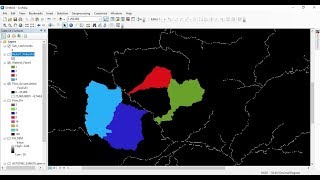
How to use a DEM to delineate a Watershed/Basin in ArcGIS

A watershed is the upslope area that contributes flow to a common outlet as concentrated drainage. It can be part of a larger watershed and can also contain smaller watersheds, called subbasins.
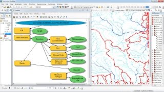
This tutorial shows step by step how to delineate a Watershed using a DEM and ArcGIS Hydrology tools.
For more information, visit our website: http://mondegeospatial.com/howtous...
Like our page on Facebook: / mondegeospatial
Share this video : • How to use a DEM to delineate a Water...
Subscribe to our Channel : / @mondegeospatialcom
Follow us on Twitter: / mondegeospatial
Follow us on Google+ : http://plus.google.com/+Mondegeospati...
Follow us on Pinterest: / geospatialgis
watershed arcgis
watershed arcgis tutorial
watershed arcgis 10
watershed arcgis 10.1
watershed arcgis 10.2
watershed arcgis 9.3
watershed arcgis problems
watershed arcgis online
arcgis watershed delineation
arcgis watershed delineation tutorial
delineation basin and watershed arcgis
delineate watershed arcgis
watershed delineation arcgis 10.1
watershed analysis in arcgis
watershed delineation arcgis
watershed delineation
watershed delineation using DEM / spatial analyst in Arcgis
Automatic Extraction of Watershed using DEM data
Delineating Watershed and Basins Using ArcGIS
extract streams and define a basin from ASTERdemarcgis / watershed delineation
How to delineate a watershed using a DEM: Mosaic, sink fill, flow direction
Compute watershed grids: fill, flow direction, and flow accumulation