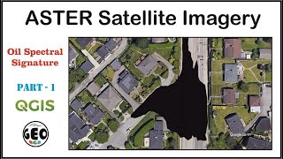
HYPERION hyperspectral imaging READY TO GO!! with Google Earth Engine and QGIS 3.14

This is how to explore Hyperion data with Google Earth Engine and to handle it with QGIS package. It would be helpful for data visualization and data analysis.
Sometime, the gdal_merge.py function doesn't work out in python 3. Google Earth Engine (GEE) also provides EO1 Hyperion Hyperspectral imager which HYPERION hyperspectral imaging data with 242 bands Geotiff format file, through Earth Engine Data Catalog [1].
In this YouTube video, I will guide how to search and select Hyperion image with JavaScript, and then how to manipulate it with QGIS 3.14 package [2]. Just make sure that some bands of Hyperion data on GEE are not calibrated and not included into EE assets [3] [4].
A false colour composite Hyperion data also shows digital number (DN) of cloud cover is somewhat higher than snow or ice cover area in the western part of Greenland like what a previous literature showed in MERIS derived measurements on the ENVISAT satellite [5].
Please subscribe to my Youtube channel and to like my posts. Enjoy it!
➤Utilities and applications:
OBS Studio (Version 26.0.2 64bit)
Win Movie Maker (Version 8.0.7.2 purchased and registered)
Vrew 0.6.5 PIXLR (https://pixlr.com/)
➤ Computer and hardware used:
My laptop: https://amzn.to/3iStQD5
Monitor: https://amzn.to/3iMx1fu
Display Port (DP) to HDMI Cable: https://amzn.to/36VHDGE
Pin microphone: https://amzn.to/3di11ig
BGM: Late night drive (Nat Keefe & BeatMower) in Audio library / YouTube Studio
➤ Accessory
Voltage Converter and Transformer, 2500 Watts: https://amzn.to/3f16jzx
DISCLAIMER: Links included in this description might be amazon affiliate links. If you purchase a product with the links as above, I may receive a small amount of commission. There is no additional charge to you for sure!
#GoogleEarthEngine #Hyperionhyperspectral #hyperspectralimaging #QGIS3
#QGISpackage #Hyperiondata #EO1HyperionHyperspectral #datavisualization #dataanalysis
#cloudcoverandsnow #cloudcoverandice #JavaScript #earthobservation
➤ Reference
[1] https://developers.google.com/earthe...
[2] https://qgis.org/en/site/forusers/vis...
[3] https://www.usgs.gov/centers/eros/sci...
[4] https://www.usgs.gov/centers/eros/sci...
[5] Schlundt, C., Kokhanovsky, A. A., von HoyningenHuene, W., Dinter, T., Istomina, L., and Burrows, J. P.: Synergetic cloud fraction determination for SCIAMACHY using MERIS, Atmos. Meas. Tech., 4, 319–337, https://doi.org/10.5194/amt43192011, 2011.
@ 2020 by TWO & Solutions. All rights are reserved.