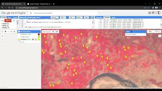
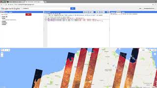
I exported 1000 sq. km of imagery in Google Earth Engine (GEE)

Code link: https://colab.research.google.com/dri...
Error: Export too large: specified 31867032 pixels (max: 100000000). Specify higher maxPixels value if you intend to export a large area. (Error code: 3).
Time stamps:
0:00 Statement of problem
0:30 Introduction to GeeDim Package
0:44 AOI in geojson.io
1:08 Initialize code in google Colab
3:25 Download imagery script
8:34 Visualize the imagery in QGIS
Google earth engine (#gee) solved issue. Export error. Too much pixel
#googleearthengine #largeaoi #export
Here are some playlists that you might be interested in:
1. Leaflet from basic to advance: • Leaflet from basic to advance
2. GeoServer with leaflet webGIS: • GeoServer and Leaflet WebGIS
3. GeoDjango project: • Bookmark note on map | GeoDjango tuto...
4. geoserverrest: • geoserverrest
5. GIS training in Nepali: • Beginner GIS training in Nepali | Arc...
6. LULC map production: • LandUse Land Cover Map production || ...
7. Geospatial analysis with python: • GeoSpatial analysis with python
8. GeoNode from basic to advance: • GeoNode from basic to Advance
9. Machine learning from the basic: • Machine Learning for geospatial data
Check out my discounted courses at the following link:
1. "Geospatial data analysis with python": https://www.udemy.com/course/geospati...
2. "Web GIS Development 2021": https://www.udemy.com/course/webgis...
3. "Web mapping and WebGIS from Dev to Deploy 2021: GeoDjango": https://www.udemy.com/course/webmapp...
4. "Introduction to Web Mapping and Web GIS 2020: GeoDjango": https://www.udemy.com/course/introduc...
5. Deep Learning Application for Earth Observation: https://www.udemy.com/course/deeplea...
6. Geospatial Data Analysis with Python: https://www.udemy.com/course/geospati...
Follow me on GitHub: https://github.com/iamtekson
Follow me on Twitter: / iamtekson
Follow me on Instagram: / iamtekson
Join Facebook group: / 1049524025731229


![FULL COURSE Google Earth Engine Python API and Colab for Absolute Beginners in 3 Hours [2023]](https://i.ytimg.com/vi/Lqirs04EccA/mqdefault.jpg)