Idaho Canyon Rip in 360 with HUD! Middle Fork Salmon River to Upper Loon Creek (U72)

*If you're seeing low resolution, check your settings and internet speed or check back in an hour. YouTube takes a hot second to process 360 in 4K or HDR. The video is/will be full glorious 4K*
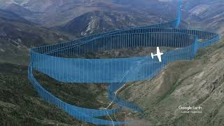
Join me on a beautiful flight up the Middle Fork of the Salmon River to Upper Loon Creek Airfield in the Frank Church River of No Return Wilderness in The Backcountry Bogey, RANS S21. The telemetry was generated by my onboard Garmin G3X Touch avionics, filmed on the insta360 x4 camera. Please let me know in the comments of how I can improve videos like this. Would you like to see other virtual gauges? Positioning of the gauges? I hope you enjoyed this VR tour in immersive 360.
Equipment used:
Insta360 x4
Zoom F2 Field Recorder
Final Cut Pro
Telemetry Overlay
Garmin G3X flight data recorder
RANS S21
Consider following Cleared Direct on IG at / cleared_direct_resources
0:00 Sulphur Creek & Morgan Ranch
2:43 Indian Creek S81
5:41 Thomas Creek 2U8
7:34 Mahoney Creek 0U3 & Cougar Ranch D47
11:31 Lower Loon C53
19:29 Upper Loon U72
@insta360 @TelemetryOverlay @garminaviation