Free views, likes and subscribers at YouTube. Now!

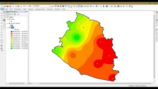
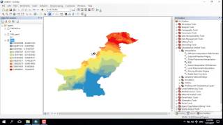
IDW Estimation Technique in GIS || Interpolation in GIS by IDW Technique

This tutorial is about interpolation in GIS by Inverse Distance Weighting (IDW) Technique.
Inverse distance weighting (IDW) is a type of deterministic method for multivariate interpolation with a known scattered set of points. The assigned values to unknown points are calculated with a weighted average of the values available at the known points.
Hope you will find it best for learning from BEST SOLUTION LINE.


Recommended