15 Free YouTube subscribers for your channel

Image Classification Through Support Vector Machine (SVM) in ArcGIS| LULC Mapping In ArcGIS

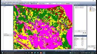
In this video, we will do Land use land cover Classification Using SVM Algorithm in ArcGIS Desktop.
1. First, we make a shapefile of training sites for different Classes like Waterbodies, Forest, Agriculture Land, Built up etc.
2. We will add two fields of attributes in that shapefile.
• Classname
• Classvaue
3. When we done training sites samples then we do next step for classification.
1. Train support vector Machine tool
2. Classify Raster
If you faced any type of errors in your classification, please feel free to contact me. I will be available for your help.
Thank you.
You can ask anything about this tutorial, please feel free to contact me on my WhatsApp number 7529918160.


![Rice Mapping using Sentinel 1, 2 in Earth Engine [GEE]](https://i.ytimg.com/vi/We9VoweOuhM/mqdefault.jpg)


Recommended