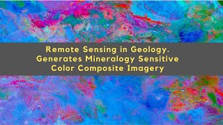
Image classification using Landsat 8 image in ENVI (Supervised)

Supervised image classification is the procedure most often used for quantitative analysis of remote sensing image data. It rests upon using suitable algorithms to label the pixels in an image as representing particular ground cover types, or classes. Supervised image classification is based on the idea that a user can select sample pixels in an image. are representative of specific classes and then direct the image processing software to use these. training sites as references for the classification of all other pixels in the image.
in this video, we've applied many methods of supervised classification such as Mahalanobis Distance Classification, Parallelepiped Classification, Maximum Likelihood Classification, Minimum Distance Classification, Neural Net Classification, and Support Vector Machine Classification Methods on Landsat 8 images in the ENVI 5.6 software.
By following the video you can apply any method in the video to your image.
====================================
Subscribe to our channel and Like the video:
✅ / channel
_ _ _ _ _ _ _ _ _ _ _ _ _ _ _ _ _ _ _ _ _ _
Share the video with others:
✅ • Image classification using Landsat 8 ...
=========================================================
Timeline:
00:00 Image classification
00:31 Preprocessing Landsat 8 images
01:09 Radiometric calibration Landsat 8
01:50 QUick atmospheric calibration Landsat 8
02:18 Surface reflectance Landsat 8
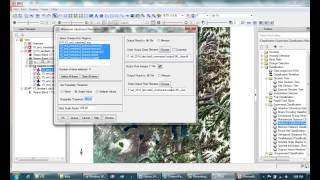
04:18 Creating ground truth ROIs in ENVI
08:25 Maximum Likelihood Classification in ENVI
09:09 Minimum Distance Classification in ENVI
09:44 Support Vector Machine Classification in ENVI
10:25 Neural Net Classification in ENVI
11:41 Parallelepiped Classification in ENVI
12:17 Mahalanobis Distance Classification in ENVI
13:41 Accuracy Assessment in Envi
=========================================================
Image classification using Landsat 8 image in ENVI 5.6 (Supervised)
#Image_classification #Landsat_8 #ENVI #Supervised #Landsat_8_image #Image_classification_using_Landsat_8 #remotesensing #GIS RS & GIS #RSandGIS