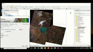
Image Fusion in the ENVI (Highly increase the Resolution) - ENVI tutorial

The image Fusion process is defined as gathering all the important information from multiple images, and their inclusion into fewer images, usually a single one. This single image is more informative and accurate than any single source image, and it consists of all the necessary information. The purpose of image fusion is not only to reduce the amount of data but also to construct images that are more appropriate and understandable for the human and machine perception. There are different methods for image fusion that each of them has its own result. in this video we utilize GramSchmidt, Principal Components, HSV and Color Normalized (Brovey) methods to perform image Fusion.
if you have any question, you can ask in the comments.
Subscribe to our channel and Like the video:
✅ / channel
_ _ _ _ _ _ _ _ _ _ _ _ _ _ _ _ _ _ _ _ _ _
Share the video with others:
✅ • Image Fusion in the ENVI (Highly incr...
__________________________________________________________________
Tags:
Image Fusion in the ENVI (Highly increase the Resolution)
#Fusion #Image_Fusion #Tutorial #ENVI #GIS #Remote_sensing #Remote_sensing_and_gis #Image_Fusion_in_the_ENVI #Tutorial_Image_Fusion #Tutorial_Image_process #Tutorial_Image_processing #Image_processing #Landsat #QGIS #SNAP #Google_earth_engine #ArcGIS #ArcMap #envi_image_sharpening #pan_sharpening #image_sharpening #pan_sharpening_in_envi #how_to_do_image_sharpening RS & GIS #RSandGIS


![Azure Data Factory Beginner to Pro Tutorial [Full Course]](https://i.ytimg.com/vi/DLmlFlQGQWo/mqdefault.jpg)