Image Processing in ArcGIS Pro Complete Tutorial

Image Processing in ArcGIS Pro is what we've covered in this tutorial. But what does it mean? Let's start with a bit of definition.
➡ ArcGIS Pro is the latest professional desktop GIS application from Esri. With ArcGIS Pro, you can explore, visualize, and analyze data; create 2D maps and 3D scenes, and share your work to your ArcGIS Online or ArcGIS Enterprise portal.
➡ ArcGIS Pro contains many tools and raster functions that work with imagery and raster data. Regardless of whether your pixelbased data is an image from a satellite, an aerial sensor, a raster dataset, or a DEM, there are many ways that you can work with this data when performing analysis. It has many Image Processing tools such as Extensions, Geoprocessing Tools, Ortho Mapping, Classification, Deep Learning, and so many other features.
____________
The whole features and Tools resolved us to Create a complete Tutorial for image processing in ArcGIS Pro. if you have any questions about the video, you can ask in the comments.
Subscribe to our channel and Like the video:
✅ / @rsgis6997
_ _ _ _ _ _ _ _ _ _ _ _ _ _ _ _ _ _ _ _ _ _
Share the video with others:
✅ • Image Processing in ArcGIS Pro Comple...
=========================================================
ArcGIS Pro Complete Beginner's Tutorial ArcGIS Pro Full Course
✅ • ArcGIS Pro Complete Beginner's Tutori...
Create Account in USGS Earth Explorer and Download Landsat 8 satellite images
✅ • Create Account in USGS Earth Explorer...
TimeLine:
00:00 Introduction
00:25 Create a New Project
01:10 Base Map in ArcGIS Pro
02:06 Imagery
02:46 Landsat8 Image
03:25 Open Landsat 8 in ArcGIS Pro
04:55 Symbology
05:48 Band Combination
07:12 Stretch Type
08:15 Swipe
08:46 Apparent Reflectance
09:53 NDVI Index
11:53 Export Raster in ArcGIS Pro
12:25 Creating Spectral Indices in ArcGIS Pro
12:58 Creating Iron Oxide in ArcGIS Pro
13:29 Creating EVI in ArcGIS Pro
14:15 Creating SAVI in ArcGIS Pro
14:50 Creating NDVI in ArcGIS Pro
15:27 Export Raster
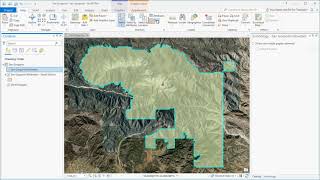
16:22 Clip Raster in ArcGIS Pro
18:04 Training Samples in ArcGIS Pro
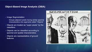
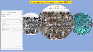
25:56 Image Classification in ArcGIS Pro
Image Processing in ArcGIS Pro Complete Tutorial
#rsandgis #gis #arcgispro #Arcgis #gistutorial #image #imageprocessing