Secret weapon how to promote your YouTube channel

Import 3D Google Maps into SketchUp Using PhotoCatch (MacOS Photogrammetry)

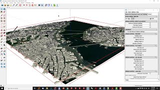
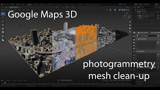
We look at the process of creating a 3D model from Google Earth (or Google Maps) using the photogrammetry (MacOS) application called PhotoCatch. PhotoCatch creates a 3D file from images or a video. We import a video from a screen recording of Google Earth. The saved PhotoCatch 3D file is imported into SketchUp using an .OBJ importer plugin called Simlab Soft.
Depiction Website:
www.depiction.com
PhotoCatch:
https://www.photocatch.app
Simlab Soft:
https://www.simlabsoft.com


![Google Maps to Blender 2023 WORKFLOW [NO BS GUIDE]](https://i.ytimg.com/vi/hrDW0Gh0tx4/mqdefault.jpg)
Recommended