Interpreting aeromagnetic data to aid mapping undercover and structural analysis of the Tanami

ASEG Webinar
Title: Interpreting highresolution aeromagnetic data to aid mapping undercover and structural analysis of the Tanami Region and northwest Aileron Province
Date: Mar 23, 2021
Presenters: Teagan Blaikie and Helen McFarlane of CSIRO
Abstract:
Interpreting highresolution aeromagnetic data to aid mapping undercover and structural analysis of the Tanami Region and northwest Aileron Province
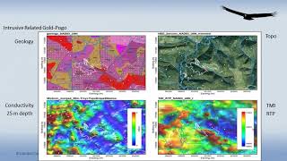
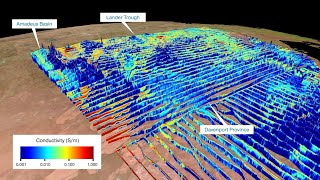
The Tanami Region, located 600 km to the northwest of Alice Springs, preserves an important record of basin development, deformation, magmatism, and the assembly of the North Australian Craton during the Paleoproterozoic. The area is also highly prospective for gold, preserving several deposits including Callie, Tanami, Granites and Groundrush. Extensive cover has made geological studies in this region challenging and has resulted in uncertainty on stratigraphic and structural relationships between some units. Recently, 200 m line spaced aeromagnetic data was acquired across the region by the Northern Territory Geological Survey. This data, together with previously acquired gravity and seismic data were interpreted to produce a new solid geological map and structural interpretation of the region. This presentation will showcase the new interpretations and discuss implications for stratigraphic relationships, and the nature and timing of deformation events which have affected the region. This work was completed as part of a collaborative project between the CSIRO and NTGS