Introduction to Geographic Information Systems (GIS) Data with R
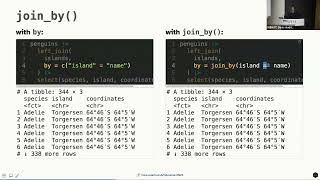
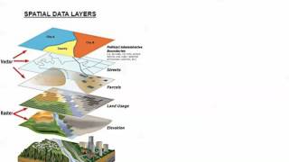
This is the second workshop in the Georgia Policy Lab's 2021 Summer Training series. In this workshop, you will learn how to use R to work with geographic data, conduct special GIS calculations, and create beautiful maps. You will learn how to find special geographic datasets (or shapefiles) and import them into R with the sf package; filter, summarize, reshape, rearrange, and manipulate geographic data with the dplyr package; convert geographic data between different map projections; create maps (both simple and complex) with the ggplot2 package; and geocode your own data with the tidygeocoder package.
This workshop was facilitated by Dr. Andrew Heiss, an assistant professor in the Department of Public Management and Policy in the Andrew Young School of Policy Studies at Georgia State University. Find more trainings on our website at https://gpl.gsu.edu/capacitybuilding/.'>https://gpl.gsu.edu/capacitybuilding/.
Workshop materials
https://talks.andrewheiss.com/2021gp...
Visit our website
https://gpl.gsu.edu/
Follow us on Twitter
/ gapolicylabs
Follow us on LinkedIn
/ gapolicylabs
Subscribe to our newsletter
http://eepurl.com/gRgof