Introduction to Python and Geopandas for Flooded Area Analysis - Tutorial

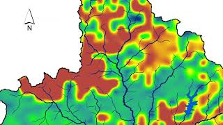
Geopandas is one of the most advanced geospatial libraries in Python because it combines the spatial tools of Shapely, it can create and read different OGC vector spatial data, it can couple the Pandas tools to manage, filter, and make operations over the columns of the metadata, it has the capability to plot geospatial data on Matplotlib and even to Folium among other features. We have developed a tutorial of Geopandas applied to the analysis of flooded areas over the Boise city for a return period of 200 years; the tutorial covers introductory concepts of Geopandas, it will work with point, line and polygon vector data, create plots, simplify vertices and perform geospatial queries over inundated facilities and highways.


![Animating Plots In Python Using MatplotLib [Python Tutorial]](https://i.ytimg.com/vi/bNbN9yoEOdU/mqdefault.jpg)