Rock YouTube channel with real views, likes and subscribers

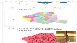
Introduction to Spatial Data Analysis with Python

by Jenny Palomino
Attendees will learn about geoprocessing, analyzing and visualizing spatial data using Python and how it compares to other available options such as desktop GIS options (ArcMap or QGIS) or R. The talk will introduce various Python projects such as PySAL, GeoPandas, and Rasterio, and give attendees a starting place for independently exploring and learning geoprocessing skills using Python.


Recommended