Secret sauce that brings YouTube followers, views, likes

Isohyetel method on Arc GIS | Calculation of area between contours

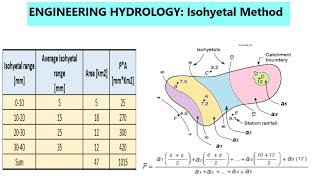
The isohyetal method is used to estimate the mean precipitation across an area by drawing lines of equal precipitation. The method uses topographic and other data to yield reliable estimates. Isohyets are contours of equal precipitation analogous to contour lines on a topographic map.
Subscribe: / aarishmaqsood
Twitter: / aarishofficial
LinkedIn : / aarishmaqsood
Instagram: / aarishmaqsood
Facebook: / aarishmaqsood
My Playlists: • Thiessen polygon method on Arc GIS | ...
#AarishMaqsood #IsohyetalMethod
Music: Melody loops


Recommended