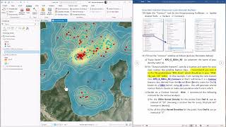
Kernel Density Tool ArcGIS

Kernel Density Tool, Density Toolset, Spatial Analyst ArcToolbox
summary
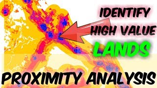
Calculates a magnitudeperunit area from point or polyline features using a kernel function to fit a smoothly tapered surface to each point or polyline.
Usage
Larger values of the search radius parameter produce a smoother, more generalized density raster. Smaller values produce a raster that shows more detail.
Only the points or portions of a line that fall within the neighborhood are considered in calculating density. If no points or line sections fall within the neighborhood of a particular cell, that cell is assigned NoData.
Very large or very small values in the Population field can give results that may seem unintuitive. If the mean of the population field is much bigger than 1 (for example, as with city populations), the default search radius might be very small, resulting in small rings around the input points. If the mean of the population field is much smaller than 1, the calculated bandwidth might seem unreasonably large. In these cases, you may want to enter your own search radius.
The Output cell size can be defined by a numeric value or obtained from an existing raster dataset. If the cell size has not been explicitly specified as the parameter value, it is derived from the Cell Size environment if it has been specified. If the parameter cell size or the environment cell size has not been specified, but the Snap Raster environment has been set, the cell size of the snap raster is used. If nothing is specified, the cell size is calculated from the shorter of the width or height of the extent divided by 250, where the extent is in the Output Coordinate System specified in the environment.
If the cell size is specified using a numeric value, the tool will use it directly for the output raster.
If the cell size is specified using a raster dataset, the parameter will show the path of the raster dataset instead of the cell size value. The cell size of that raster dataset will be used directly in the analysis, provided the spatial reference of the dataset is the same as the output spatial reference. If the spatial reference of the dataset is different than the output spatial reference, it will be projected based on the selected Cell Size Projection Method.
For ArcGIS 10.2.1 and later, the default search radius (bandwidth) is calculated based on the spatial configuration and number of input points. This approach corrects for spatial outliers—input points that are very far away from the rest—so they will not make the search radius unreasonably large.
If the area unit scale factor units are small relative to the features (distance between points or length of line sections, depending on feature type), the output values may be small. To obtain larger values, select the area unit scale factor for larger units (for example, square kilometers versus square meters).
The density calculations are dependent on accurate distance and area calculations. It is recommended that in most cases the GEODESIC method should be used. The PLANAR method may be appropriate if the analysis is to be performed on a local area with a projection that accurately maintains the correct distance and area. See Learn more about geographic and projected coordinate systems for determining appropriate projections.
kernel density ,kernel density estimation ,kernel density arcgis ,density ,kernel density arcgis tutorial ,kernel ,kernel density arcmap ,#kernel density ,kernel density in arcgis ,kernel density in arcpro ,kernel density arcgis pro ,argis kernel density ,kernel density in gis ,kernel density nedir ,point density arcgis ,arcgis 10.6 kernel density ,arcgis pro: kernel density ,point density ,how kernel density works ,kernel density estimation arcgis
Explanation of the tool:
https://gisforwe.blogspot.com/2022/01...
Follow the GISforWE website here:
https://bit.ly/GISforWE
A site for anyone interested in the field of GIS from here:
https://gisforwe.blogspot.com/
Proficiency in dealing with geographic data through ArcGIS programs:
• احترف التفاعل مع البيانات من خلال برا...
Learn the basics of creating geodatabases from here:
• أساسيات بناء قواعد البيانات الجغرافية...
Here is a page and a group on Facebook to learn more about Geographic Information Systems (GIS) and ArcGIS programs through these links:
ArcGIS Facebook group:
/ 486795389231905
Facebook group GIS for WE ArcGIS:
/ esri.arcgis
GIS for WE Facebook page:
https://www.facebook.com/profile.php?...
Video link for an introduction to learning on ArcGIS programs in three stages:
• مقدمة دورة تعلم ArcGIS بثلاثة مراحل |...
#ArcGIS
#Analysis_GIS
#Data_Analysis
Prepared and presented by the developer and researcher in the field of geographic information systems, Hossam Jubeh
Ramallah Palestine.
#GISforWE
GIS for the World of ELearning