Kriging Interpolation. Exploratory Data Analysis. Groundwater Flow. QGIS Rstudio and ArcMAp. #2
To learn more about Geo RGB, visit us at:
https://giscourse.online
Contact us at:
[email protected]
Kriging Interpolation. Exploratory Data Analysis. Groundwater Flow. QGIS, Rstudio and ArcMAp. #2
Histogram, Frequency curve and Normal QQ plot.
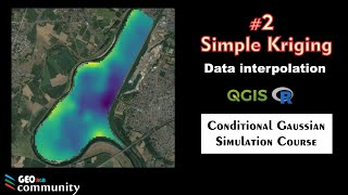
Groundwater flow map. Kriging Interpolation with Rstudio compared with kriging interpolation with ArcMap. QGIS edition for the groundwater flow map. Geostatistical analysis course. Exploratory data analysis, Gaussian distribution, trend analysis, sampling homogeneity, data transformation, histogram, normal QQplot, voronoi map. Experimental Semivariogram, anisotropy, trend removal, semivariogram cloud, omnidirection semivariogram, directional semivariogram, variance map. Model Semivariogram, automatic Semivariogram model fit. Cross validation, prediction error, scaterplot, error calculation. Universal kriging interpolation, Ordinary kriging interpolation, prediction map, standard deviation map. Map edition. Coding with R, Rstudio. Geographic information systems. Geostatistical estimation of hydrogeological parameters study. Kriging for Estimating Hydrogeological Parameters.