Lake and River Water Quality : NDCI and NDWI Analysis with Google Earth Engine (Water Analysis GIS).

Explained How To Compute NDWI and NDCI To Exploring Water Bodies: Remote Sensing with Sentinel2 Imagery
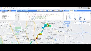
Join us on a fascinating journey as we utilize Sentinel2 satellite imagery to explore water bodies, focusing on Manchar Lake as our prime example. In this tutorial, we delve into the intricate process of image visualization and analysis, uncovering the secrets hidden within the data.
Key Points Covered:
Defining Area of Interest (AOI) and understanding image visualization techniques.
Filtering Sentinel2 data to extract relevant information about Manchar Lake.
Identifying water bodies using the Normalized Difference Water Index (NDWI).
Assessing chlorophyll presence in water using the Normalized Difference Chlorophyll Index (NDCI).
Creating a vivid legend to interpret the color scale of NDCI images.
Video Chapters:
Introduction to AOI and image visualization
Filtering Sentinel2 data for Manchar Lake
Water identification using NDWI
Chlorophyll assessment with NDCI
Crafting an informative legend for NDCI visualization
Recommended for:
Machine Learning in GIS
Google Earth Engine
Remote sensing enthusiasts
GIS practitioners
Environmental researchers
Stay Connected:
Don't forget to like, share, and subscribe for more insightful tutorials on geospatial analysis and remote sensing techniques. Hit the bell icon to receive notifications for our upcoming videos!