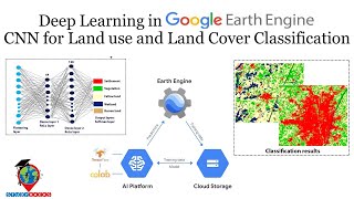
Land Cover Classification using a Simple Deep Learning Model (TensorFlow) with Earth Engine Data

Hi Geospatial Enthusiast!
Would you like to classify land cover classification using a deep learning model such as Convolution Neural Network? In this video, I will show you how to use Earth Engine imagery and samples to build a land cover classification model in TensorFlow (Keras).
GEE script: https://code.earthengine.google.com/4...
Colab script: https://colab.research.google.com/dri...
The image used is the 2023 Landsat 8 and 9 composite of Jambi City, Indonesia. The land cover classes I use are builtup, bare land, water, wetland, herbaceous, dry shrub, wet shrub, palm oil, and plantation forest. Other than the spectral band from Landsat, the features or variables I use are the spectral indices and elevation from SRTM. The images/variables and extracted samples will then be exported to Google Drive where they will be mounted and used in Colab.
For the model, I am using a combination of Dense and Convolutional 1dimensional layers. My model is far from perfect, you could improve it more. Also, this is 1 dimensional (tabular), you could use more dimensions using spatial data instead of extracted tabular data.
I hope this video helps with your research or project.
Email: [email protected]
Linkedin: / ramiqcom
GitHub: https://github.com/ramiqcom


![FULL COURSE Google Earth Engine Python API and Colab for Absolute Beginners in 3 Hours [2023]](https://i.ytimg.com/vi/Lqirs04EccA/mqdefault.jpg)