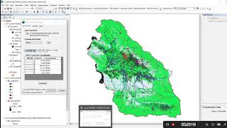
Land use Map for SWAT Model- Maximum Likelihood Classification ENVI

How to generate land use map for SWAT model: Using Envi, Maximum Likelihood classification
While you can always use prepared global land use maps, there are some benefits to making your own classification map. You need some tools in order to follow this tutorial which is: Arcmap (10.2), Envi(5.3), and satellite image (Landsat 8 OLI).
You need to have two images: One of them is natural color (for collecting ROI) and the second is the image for running the algorithm which contains several bands.
First of all, make a natural band combination. natural color composite for Landsat 8 contains bands number 4,3 and 2. You can always search for these band combinations using the web (as I did in the video).
Then you should make the second image. For making this image you need to stack these layers: natural color, NDVI, NIR, Slope. You have already made the natural color layer. So now you want NIR. NIR is the band number 5 in Landsat 8. Now it's time to make the NDVI. You need bands Red and NIR. You have just made NIR, so let's prepare the Red band. Then composite these two in order to have on the image containing two bands (NIR and Red). Bring images to ENVI and use the NDVI command. Another layer that you need, is the slope. If you need some tutorials for making the slope layer, let me know.
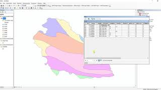
Now it's time to collect ROI. Open naturalcolor image in ENVI and collect efficient and accurate ROIs. You can have as many classes as you want, so don’t panic! After collecting all ROIs for your desired classes, Run the Algorithm, and you are Done!
This is a timeconsuming process and getting accurate results with the first try, is too rare! So be patient and go through it.
Step by step guide to generating land use map for SWAT model: maximum likelihood classification ENVI
Tags:
SWAT Model,land use map,Land use Map for SWAT Model Maximum Likelihood Classification ENVI,Maximum Likelihood Classification Landsat 8 oli download, Landsat 8 oil, swat
swat model tutorial,swat model tutorials envi tutorial land use, Landsat 8 OLI, using envi
swat model, swat modelling swat modeling, swat model setup land use map for swat model
word soil map,map for the swat,maximum likelihood classification algorithm maximum likelihood classification


![The moment we stopped understanding AI [AlexNet]](https://i.ytimg.com/vi/UZDiGooFs54/mqdefault.jpg)