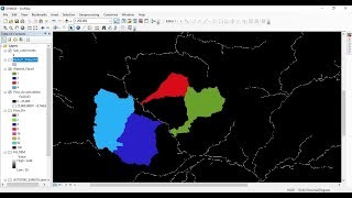
Landcover Change Detection using Landsat 8 (Australian Forest Fires 2019-2020)

This is a tutorial which explains how you can use remote sensing and GIS to perform a landcover change analysis with the aid of Landsat 8 images. This tutorial covers parts such as:
1. Creating a multiband composite of Landsat 8
2. Identifying changes visually and through the calculation of the 'Difference'
3. Perform an unsupervised classification
4. Computing the damaged areas
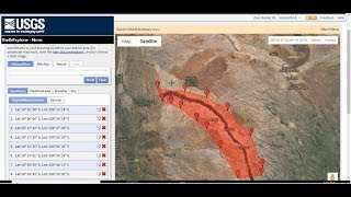
Download Landsat 8 images https://earthexplorer.usgs.gov/
⭐NOTE:
‘Kite’ is an excellent tool that can help you boost your productivity when it comes to programming with its free Artificial Intelligence (AI) powered coding assistant. Kite is a plugin which provides smart completions and documentation as you’re typingin your code, and its compatible with most of the wellknown IDEs such as PyCharm, Spyder and VS Code. I absolutely love it, and recommend you guys to try it out as well.
https://www.kite.com/getkite/?utm_me...