Landsat 9 | Image Classification| Supervise Classification in ArcGIS | Land use u0026 Land Cover Map

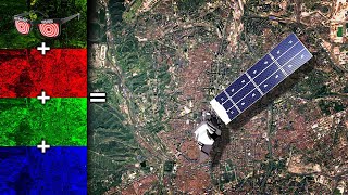
The video tutorial demonstrates how to create a LandUse LandCover (LULC) map using supervised classification in ArcGIS. It covers the process of importing Landsat 9 imagery, preparing the data through preprocessing, collecting representative training data for each landuse class, and implementing supervised classification using suitable algorithms. The tutorial emphasizes the importance of the LULC map and concludes with extracting area statistics for each landuse category. Whether you're a GIS enthusiast or a professional, this tutorial equips you with the skills to create precise and informative LULC maps from satellite imagery.
xxx
New ArcGIS learners follow below video sequence:
1 Introduction to ArcMap and its basic features: • Geoprocessing in ArcGIS | ArcGIS Basi...
2 How to create a shapefile in ArcMap: • GIS |How to make a shapefile in Arcma...
3 How to edit shapefile in ArcMap: • How to edit shapefile in Arcmap: ArcG...
4 How to add a field in ArcMap attribute table: • Adding field in shapefile attribute t...
5 How to calculate area in ArcMap: • How to calculate polygon area in ArcM...
6 Join and relates Excel table with attribute table in ArcMap: • Join and relates excel table with att...
7 Geoprocessing in ArcGIS: • Geoprocessing in ArcGIS | ArcGIS Basi...
8 How to create a geodatabase in ArcGIS: • How to create geodatabase in ArcGIS
9 Thematic Maps Part 1: • Thematic Maps | Graduated Colors | Gr...
10 Thematic Maps Part 2: • Thematic Map | Multiple Attributes | ...
11 Thematic Maps Part 3: • Thematic Maps | Charts in ArcGIS | Ar...
12 How to Calculate Population Density: • Thematic Map | How to calculate popul...
13 How to create a map layout in ArcMap: • ArcGIS Map Layout : ArcGIS Basics
14 Labeling and annotation in ArcMap: • Labelling and annotation in ArcGIS | ...
15 Importing Excel coordinate to ArcGIS: • Importing excel coordinates to ArcGIS
16 How to export maps from ArcMap: • Export maps from arcmap: ArcGIS Basics
17 How to create buffers in ArcMap: • Export maps from arcmap: ArcGIS Basics
18 Georeferencing Raster with coordinate: • Georeferencing raster with coordinate...
19 Georeferencing Raster with shapefile: • Georeferencing raster data by shapefi...
20 Georeferencing raster to raster: • Raster to raster georeferencing: Geor...
21 Interpolation in ArcGIS: Kriging VS IDW: • Interpolation in ArcGIS: Kriging VS IDW
22 Clipping raster in ArcGIS: • Clipping Raster in ArcGIS : ArcGIS Ba...
23 Masking raster in ArcGIS: • Clipping raster by mask in ArcGIS
24 How to work on google earth and convert data into ArcGIS: • How to measure property area using Go...
25 How to create a data entry form in Microsoft Excel and display data on ArcGIS and Google Earth Pro.: • How to create data entry form in Micr...
26 How to extract elevation points, DEM, and Contours from Google Earth: • How to extract elevation points, DEM,...
27 How to download DEM data from earth explorer and Mosaic in ArcGIS: • How to download and mosaic DEM in ArcGIS
28 How to create contours: • How to create contours in ArcGIS | Ar...
29 Join and relate the Excel table with the attribute table: • Join and relates excel table with att...
30 How to calculate NDVI in ArcGIS using a raster calculator: • How to calculate NDVI in ArcGIS using...
31 Model Builder in ArcGIS: • Model builder in ArcGIS
xxx
#arcgis, #Imageclassification, #easylearningwithahsan,
xxx
Channel Subscription: https://bit.ly/3wHJlWD