Landsat Images - Band combination Mosaic Mask and removing black borders - ArcMap

Initial preparations of satellite images in GIS: band combination, mosaic, mask, and removing black borders
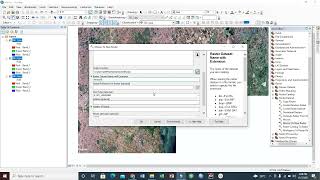
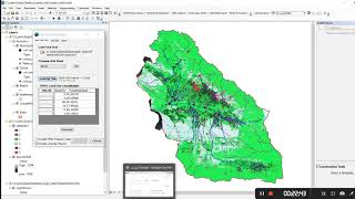
How can you use satellite images immediately after downloading from the site? In this video, we are working with Landsat images. When you open any of them in ArcMap, you see them in gray color. So the first step is to make a band combination. Different band combinations are used for studying different features. But the natural color composite for Landsat 8 is band 1,2,3. After doing so, if all of your study areas aren’t covered by only one image, you need to mosaic them. Mosaic to the new datasets is the command to use in this case. Then, you want to limit your image to your study area. Using extract by the mask can help you with that.
Tags:
Landsat band combination Landsat images, mosaic band combination, mosaic mask
band combination in ArcGIS, Lansat images band combination in Landsat, mask and removing black borders, image processing mosaic band combination Landsat in ArcGIS, band combination
removing black borders, Landsat removing black borders Landsat mask, mask in Landsat, mosaic in Landsat Landsat remove black borders in Landsat, remove black borders in Landsat images, remove black borders in the image