Learn How to Get Atmospherically Corrected Surface Reflectance Images Like an Expert

Tutorials on how to download Landsat 30m, Sentinel 10m & Atmospherically Corrected Surface Reflectance Images. Step by Step guideline to Get Atmospherically Corrected Surface Reflectance Images Like an Expert
****************************************************************
BUY Domain at Cheap Price!! : https://cutt.ly/5CEuzSD
****************************************************************
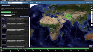
Download Atmospherically Corrected Image Here: https://cutt.ly/mVKesdQ
****************************************************************
Find Useful Tutorials:
Free Spatial Data |Shapefile| of Any Country & Humanitarian Data: https://cutt.ly/1WawYD1
Land Cover Data 10 m Resolution: https://cutt.ly/3Waqcvo
Least Cost Path: https://cutt.ly/xWaqmEb
Download Open street Map: https://cutt.ly/SWaqWFk
Stream Power Index SPI Calculation:https://cutt.ly/jWaqT9t
Topographic Wetness Index TWI Calculation: https://cutt.ly/qWaqIw5
Suitability Analysis Using Arcgis: https://cutt.ly/6WaqSnA
Add xy data from excel, clip, select, split, table select tools in ArcGIS: https://cutt.ly/mWaqGuS
Drainage or Stream Frequency & Infiltration number: https://cutt.ly/7WaqJ5U
Calculate Stream or Drainage Density: https://cutt.ly/VWaqX36
Extracting Stream or Drainage Network from DEM: https://cutt.ly/QWaqMS9
Detail Watershed Delineation using DEM: https://cutt.ly/TWaq3Lk
ArcGIS Tutorial:https://cutt.ly/qWaq7gu
Qgis Tutorial: https://cutt.ly/ZWaq6e2
Change Detection: https://cutt.ly/sWawwfX
Download Free Shapefile:https://cutt.ly/XWawrsG
Download Soil Organic Carbon, Evapotranspiration, Land cover, Precipitation Data: https://cutt.ly/cWawtFC
Human Influence Calculation: https://cutt.ly/TWawuPv
Lineaments Extraction :https://cutt.ly/sWawi3K
World Soil Map Shapefile: https://cutt.ly/tWawaxY
Hotspot / Kernel Density Analysis: https://cutt.ly/nWawgLt
GIS Shapefile Data ( Road, Structure, etc.) for Any Country: https://cutt.ly/WWawjPq
Land Cover Change Detection: https://cutt.ly/cWawleE
Soil Moisture Index and Land Surface Temperature Calculation: https://cutt.ly/tWawzhs
Calculate normalized burn ratio (NBR): https://cutt.ly/WWawxL9
Create Specific & Random Points: https://cutt.ly/CWawv6o
Keyword: earth explorer,usgs, gis,arcgis,introduction to gis,landsat,satellite,landsat 8,remote sensing,download,satellite image, landsat , download landsat 8, landsat level 1 data , esa,sentinel 2sentinel2 level2a,sentinel2,copernicus open access hub,atmospheric correction, sentinel download 18 how to download sentinel 2 image how to download sentinel 1 image, how to download sentinel 3 image , 10 meter sentinel, atmospheric corrected,surface reflectance,landsat 8, Explore RS & GIS Tutorials,Explores RS & GIS,gis,earth explorer,usgs,arcgis,landsat 8,remote sensing,satellite image,download landsat 8,landsat level 1 data,sentinel 2sentinel2 level2a,sentinel2,copernicus open access hub,10 meter sentinel,surface reflectance,landsat imagery,Get Atmospherically Corrected Surface Reflectance Images,gis for mapping,radiometric and atmospheric correction,esri,satellite imagery,satellite images,landsat,sentinel,sentinels
Contact if need
Facebook: / rsgistutorial
Twitter: / rsexplore
Linkdin: / siamkhan89236a1b9