A little secret to rock your YouTube subscribers

Lesson 3 - Making our first map in QGIS

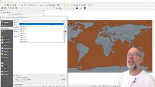
Welcome to DMAD's third online GIS lesson, you'll need to download and extract the files from DMAD's website (www.dmad.org.tr/qgislesson3). This lesson shows us how we can make use of data freely available on the internet. We will import a number of lines and polygons, learn about map layers, learn how to colour our layers, not only individually but also based on their characteristics.
Data like this can be freely downloaded from: https://divagis.org/gdata


Recommended